Severe Cyclone Storm ‘Remal’

As per The India Meteorological Department (IMD) Cyclone Remal, in the Bay of Bengal, has intensified into a “severe” cyclonic storm.
LEARNING FROM HOME/ WITHOUT CLASSES/ BASICS
The India Meteorological Department (IMD) issues color codes to indicate various categories of alerts. Here is what each alert means:
Green (All is well): No advisory is issued
Yellow (Be aware): Severely bad weather is possible over the next few days, plan thinking about possible travel delays and disruption of day-to-day activities possible. It indicates the weather may change or worsen in the next few days.
Amber (Be prepared): There is an increased likelihood of extremely bad weather, which could potentially cause travel delays, road and rail closures, and interruption of power supply. There could be a risk to life and property. Amber means people need to be prepared to change plans and protect themselves, their family and the community from the impacts of the severe weather based on the forecast from the Met Office.
Red (Take action): Extremely bad weather is expected. People need to take action to keep themselves and others safe. Widespread damage, travel and power disruption, and risk to life are likely. People must avoid dangerous areas and follow the advice of the emergency services and local authorities.
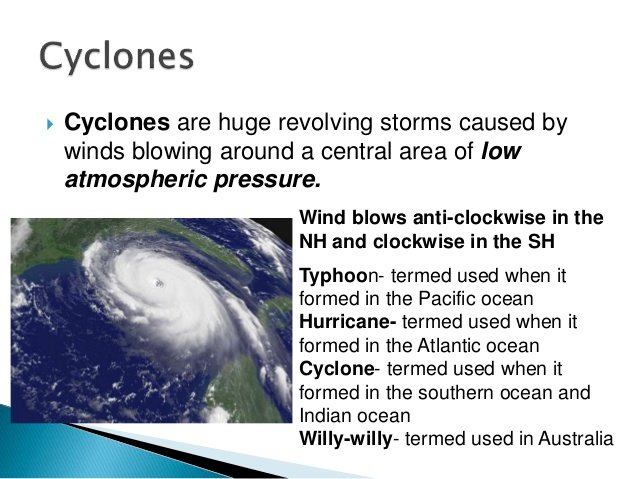
Hurricanes, cyclones, and typhoons are all the same weather phenomena. In the Atlantic and Northeast Pacific, the term “hurricane” is used.
The same type of disturbance in the Northwest Pacific is called a “typhoon” and “cyclones” occur in the South Pacific and Indian Ocean.
The ingredients for these storms include a pre-existing weather disturbance, warm tropical oceans, moisture, and relatively light winds. If the right conditions persist long enough, they can combine to produce the violent winds, incredible waves, torrential rains, and floods associated with this phenomenon.
It is characterized by a large-scale closed circulation system in the atmosphere which combines low pressure and strong winds that rotate counter clockwise in the northern hemisphere and clockwise in the southern hemisphere.
Temperate cyclone (TC) or extratropical or mid-latitude (30 to 60 degrees). In the northern hemisphere, we have these pre-existing conditions for TC
Warm air blows from the south of the front
Cold air blows from the north of the front. It sets in motion an anticlockwise cyclonic circulation. TC can originate over both land and sea. It affects a much larger area. Tropical cyclones are more destructive, as the wind velocity is much higher. Temperate moves from west to east and tropical from east to west
Extratropical cyclones have cold air at their core and derive their energy from the release of potential energy when cold and warm air masses interact. These storms always have one or more fronts connected to them and can occur over land or ocean. An extratropical cyclone can have winds as weak as a tropical depression, or as strong as a hurricane. Examples of extratropical cyclones include blizzards, Nor’easters, and the ordinary low-pressure systems that give the continents at mid-latitudes much of their precipitation.
Tropical cyclones 30 degrees to -30 degrees inside the tropicals. Tropical originates over warm oceans in tropical areas. They cause violent winds and very heavy rainfall.
Four different stages of cyclonic disturbance.
Cyclonic Storm: Max. wind speed 63-87 KMPH
Severe Cyclonic Storm: Max. wind speed 88-117 KMPH
Very Severe Cyclonic Storm: Max. wind speed 118-220 KMPH
Super Cyclonic Storm: Max. wind speed 220 KMPH and above
Divided into 5 categories as on Wind speed
Category 1 120-150 KMPH
2 150-180 KMPH
3 180-210 KMPH
4 210-250 KMPH
5 250 KMPH AND ABOVE


0 Comments