Devastating Cloud Burst Strikes Himachal Pradesh

Last week Himachal Pradesh experienced severe devastation with reports of cloud burst, floods, and heavy rains in various locations across the state.
LEARNING FROM HOME/WITHOUT CLASSES/ BASICS
Cloud Burst
is sudden copious rainfall. An extreme amount of rain happens in a short period, sometimes accompanied by hail and thunder. The India Meteorological Department (IMD) defines it as unexpected precipitation exceeding 100mm (or 10 cm) per hour over a geographical region of approximately 20 to 30 square km. Significant amounts of rainfall such as this can result in floods.
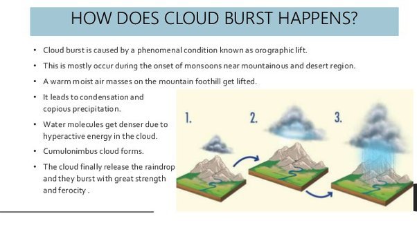
The air currents rushing upwards in a rainstorm hold up a large amount of water. If these currents suddenly cease, the entire amount of water descends onto a small area with catastrophic force all of a sudden and causes mass destruction.
This is due to a rapid condensation of the clouds. Various researches suggest that they are manifestations of intense vortices on a small scale. It generates strong convection currents, which lift the moisture-laden air with sufficient rapidity to form cumulonimbus clouds shedding water load with great strength and ferocity.
It is difficult to accurately predict and identify cloudbursts immediately. However, they are more likely to occur in mountainous zones mainly because of terrain and elevation. This is because, in hilly areas, sometimes saturated clouds ready to condense into rain cannot produce rain, due to the upward movement of the very warm current of air. Instead of falling downwards, raindrops are carried upwards by the air current. New drops are formed and existing raindrops increase in size. After a point, the raindrops become too heavy for the cloud to hold on to, and they drop down together in a quick flash.
CLOUDS
Clouds are aggregates of very small water droplets, ice crystals, with its base above the earth’s surface. A classification is made in level – high, medium, or low – at which the various cloud genera are usually encountered. In temperate regions the approximate limits are high. (16500 – 45000 ft); medium, 27 km (6500 –23000 ft); low, 02 km (0 – 6500 ft).
The high clouds are Cirrus (Ci), Cirrocumulus (Cc),Cirrostratus (Cs).
The medium clouds are Altocumulus (Ac), Altostratus and Nimbostratus (Ns) (usually extending both higher and lower);
The low clouds are Stratocumulus (Sc), Stratus (St), Cumulus (Cu), and Cumulonimbus (Cb).


0 Comments